A national RR&D4P program mapping the location and extent of all commercial olive groves in Australia is set to deliver more accurate yield forecasting across all scales – at national, regional and farm levels.
A partnership between the Australian Olive Association (AOA), Hort Innovation, the University of New England, Queensland University, Central Queensland University and the government, the project is a first for the olive industry and the map will be a baseline for all commercial (> 1 hectare) olive groves in Australia.
The development of the map builds on the success of the Phase 1: Multi-scale Monitoring Tools for Managing Australian Tree Crops, Industry meets Innovation project, where one of the major outputs included the first national map of all commercial avocado, macadamia and mango orchards. Since its launch in September 2017 as the Australian Tree Crop Rapid Response App, the map has been viewed over 6,800 times and was successfully applied in the response to Tropical Cyclone Debbie, which severely impacted the mango industry in the central coastal Queensland growing region.
The potential applications for the map are not limited to post-natural disaster monitoring: knowing the distribution and extent of commercial groves has the power to greatly inform decision-making at both farm and industry level. Potential applications include increased biosecurity preparedness, where targeted field surveys and the implementation of exclusion zones can immediately be implemented following an incursion, saving both time and money in locating high-risk groves. Additionally, the map can assist in identifying abandoned groves that present as high-risk hosts of pests and diseases.
For the industry body, the AOA, knowing the spatial distribution of olive groves provides a better understanding of industry demographics (annual spread etc), while a more accurate measure of production area can assist with improved estimation of annual production and subsequent forward selling decisions.
Privacy protection
Importantly the mapping adheres to national standards for commodity level land use mapping, supported by the Australian Collaborative Land Use and Management Program (ACLUMP), which promotes nationally-consistent land use information. Privacy concerns are acknowledged and respected as the information sources used to compile land use include remotely sensed data (imagery), state and national ancillary datasets, field observation and expert opinion.
No personal or confidential information is collected as part of the land use mapping process nor contained within the land use datasets. The map simply presents a polygon feature that denotes the specific land use, no property information (block, variety, yield, etc) nor personal information (grower, enterprise, owner) is included.
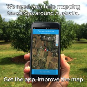
The success of the Phase 1 mapping was a direct result of the collaboration between growers and stakeholders, whose direct input and use of the Land Use Survey App provided the vital information to map the orchards. By using the App anyone can submit a land use observation (from any device, mobile or desktop – it runs in a browser) to help build this vital layer for the industry.
Let’s make it happen – get the app and improve the olive industry map!
More information
For more information on the app, map and the tree mapping program, contact Craig Shephard at craig.shephard@qld.gov.au, and view the Australian Tree Crop Rapid Response Web App here.
This component of the remote-sensing project for olives will also be included in the presentation Remote Sensing – The Sky Is The Limit by Alex Schultz of the NSW DPI at the 2019 AOA National Olive Conference & Exhibition in Albury in October. Access the program and register here.