The Australian Tree Crop Map was first imagined in 2014, when tree crop industries approached the Applied Agricultural Remote Sensing Centre (AARSC) to see whether remote sensing technology could be used to estimate the size of their respective production areas.
Through Hort Innovation, the Multi‑scale monitoring tools for managing Australian tree crops project (ST19001) was established with support from the Australian Government Department of Agriculture, Fisheries and Forestry as part of its Rural R&D for Profit program.
The project was led by the University of England, and included the national mapping of all commercial orchards to better understand industry size and annual change, as well as identifying emerging technologies that offered improved measures of tree health and yield forecasting.
In 2017 the AARSC mapping team delivered the first Australian Tree Crop Map (ATCM).
Over the past decade, the map has gone from strength to strength, with a second phase of the project in 2019 seeing banana plantations, citrus orchards and olive groves included in the map. The updated ATCM (2022) also included more detail, with a minimum mapping unit of 1 hectare.
The AARSC mapping team are now looking forward to what the next five years of further developing the map will bring. The next phase will see a significant expansion to the data and insights available about avocado, banana, citrus and macadamia crops in Australia, including additional data like planting year, variety, and land management.
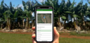
Find out more and view the ATCM here.
This program was funded by Hort Innovation with support from the Australian Government Department of Agriculture, Fisheries and Forestry as part of its Rural R&D for Profit program, with the citrus industry research and development levy, UNE Central Queensland University, AMIA, NT DITT, NSW DPI, Department of Agriculture and Fisheries Queensland (DAFQ) and Tie Up Farming.