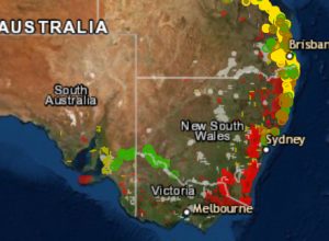
Amid devastating bushfire activity across Australia, scientists have released a map showing avocado, mango, olive, banana, macadamia and citrus orchards that have been impacted, to help with response and recovery efforts.
Driven by a Hort Innovation investment, in collaboration with various universities, state and federal government agencies, private sector companies and industry, the Australian Bushfires Rapid Response Map outlines the location of targeted treecrop farms across Australia, overlayed with a map of burned areas, which updates every 10 minutes.
The map reveals that fortunately, avocado, mango, olive, banana, macadamia and citrus orchards have suffered comparatively minimal fire damage so far this season, with the bulk of farms unscathed.
Scientist Craig Shephard, from the University of New England’s Applied Agricultural Remote Sensing Centre (AARSC), said the new tool aims to help authorities and industry bodies easily identify any crop damage and loss.
“While broad land cover maps are useful for making general assumptions and policy decisions regarding the impact of national disasters such as bushfire, industry-specific maps allow the impact and extent of the damage to be calculated,” he said.
“This data can also be useful in instances such as claiming insurance, and can help growers if they are unable to get out to assess damage themselves.”
The web map works in any browser on any smart device and offers three different base maps (imagery, terrain or streets), with a search function to find an address or place of interest.
This response map is a snapshot of work being delivered as part of a broader national tree crop mapping project. The initiative is supported by Hort Innovation, through funds from the Australian Government’s Department of Agriculture Rural R&D for Profit program and co-ordinated by the University of New England, with bushfire extent from the EMSINA Group and Geoscience Australia.
View the Australian Bushfires Rapid Response Map here.